Digital technologies are increasingly helping farmers improve decision-making, enabling more efficient use of resources and higher farm productivity. This can, in turn, support farm profitability and improve environmental outcomes such as reduced water, fertiliser and pesticide use. Satellite data in agriculture is one of the main enablers of this shift. The EU’s Common Agricultural Policy (CAP) also supports this transition. One of its ten objectives for 2023-2027 is to modernise agriculture and rural areas by fostering knowledge, innovation and digital technologies, and encouraging their uptake by farmers. [1]
Data from space plays an enabling role in many of these technologies, particularly through two sources:
EO data provides information about crop development, health and soil conditions, which farmers can use to improve decisions around irrigation, fertilisation and crop protection. GNSS provides precise positioning. This enables automatic steering of tractors and other vehicles, helping farmers operate machinery more efficiently. It also enables variable rate application, adjusting fertiliser and pesticide amounts across a field to crop needs. For example, EO can identify areas of a field showing signs of crop stress. GNSS-guided machinery then adjusts the fertiliser or pesticide rate across those areas, instead of applying one rate everywhere.
Several of the digital technologies tracked by 4Growth utilise satellite data, including:
These technologies show how data from space is being put to practical use in agriculture.
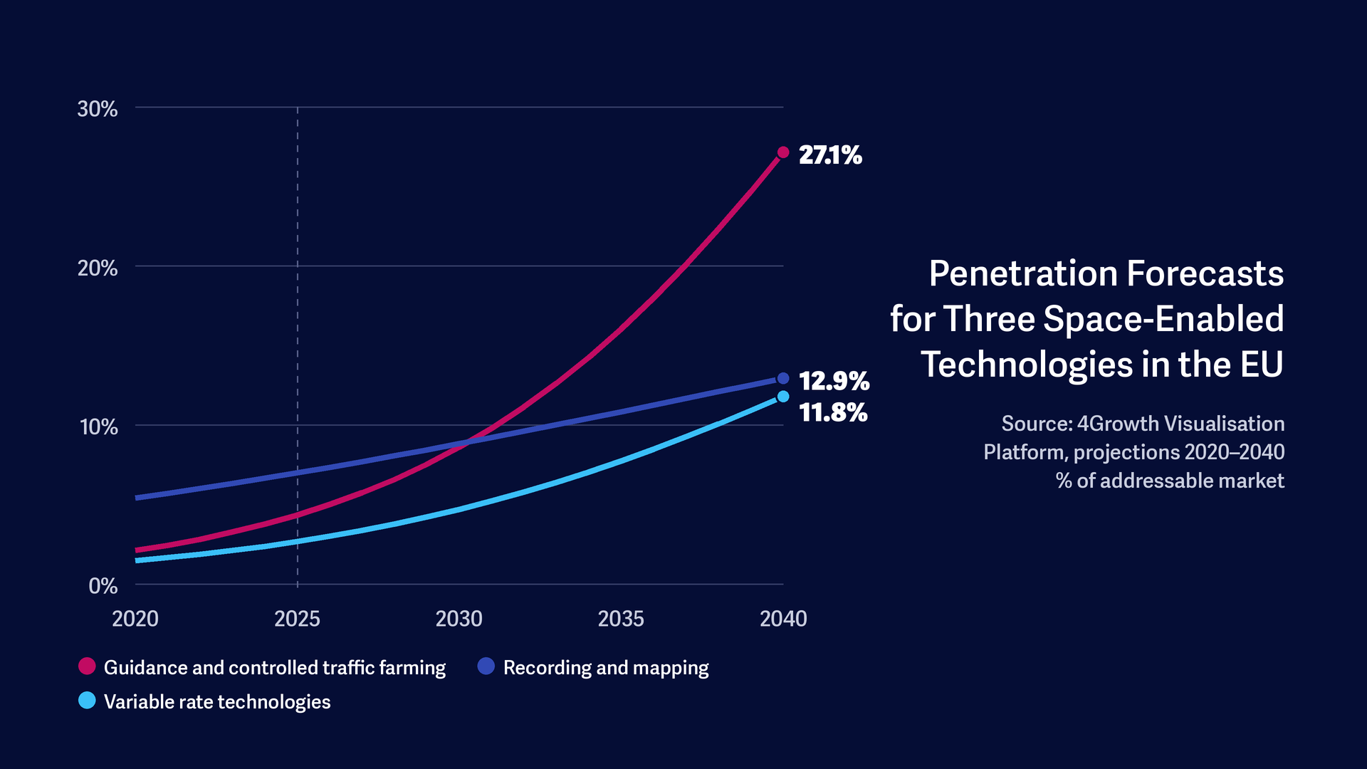
Current penetration of the three technologies in the EU remains relatively limited, but 4Growth forecasts suggest substantial increases over the next 15 years. Penetration measures how much of its addressable market a technology has reached. This is not the same as the share of farms using a technology or the share of farmland it covers, as adoption across farms and the area of land on which a technology is used can vary. VRT has an estimated penetration of 2.7% in 2025, rising to 11.8% by 2040. Recording and Mapping Technologies have a higher current penetration of 7.0%, forecast to increase to 12.9%. The strongest increase is forecast for Guidance and Controlled Traffic Farming, with penetration rising from 4.3% in 2025 to 27.1% in 2040, as shown in the figure below. [2]
The wider market for space-enabled agricultural applications is also expected to expand. The EU Agency for the Space Programme (EUSPA) forecasts that revenues from EO data and services used in agriculture will increase from almost €720 million to more than €1.9 billion globally between 2024 and 2034. In the EU, revenues are forecast to increase from around €130 million to roughly €360 million over the same period. Agriculture is already the largest segment of the EO market, with 21% of global revenues in 2024. EO helps farmers address productivity constraints as food demand grows. [3]
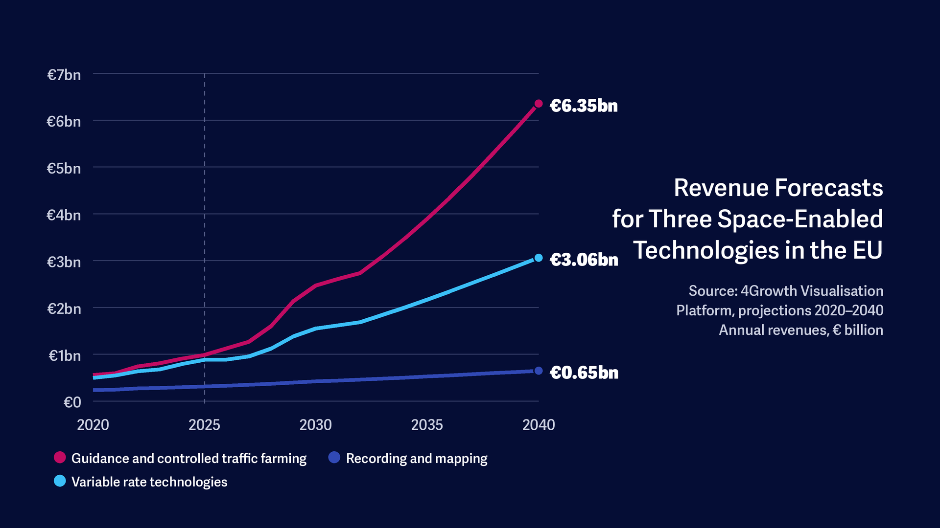
4Growth similarly forecasts substantial revenue growth for these technologies. Its estimates cover the sales value of the technologies themselves, including hardware. 4Growth expects revenues from Recording and Mapping Technologies to increase from around €310 million in 2025 to almost €650 million by 2040 (+110%). Revenues from VRT are forecast to rise from almost €880 million to more than €3 billion (+250%). The strongest growth is expected for Guidance and Controlled Traffic Farming, where revenues from guidance-equipped machinery increase from almost €990 million in 2025 to almost €6.4 billion in 2040 (+540%), as shown in the figure below. This growth closely tracks the forecast rise in penetration. [4]
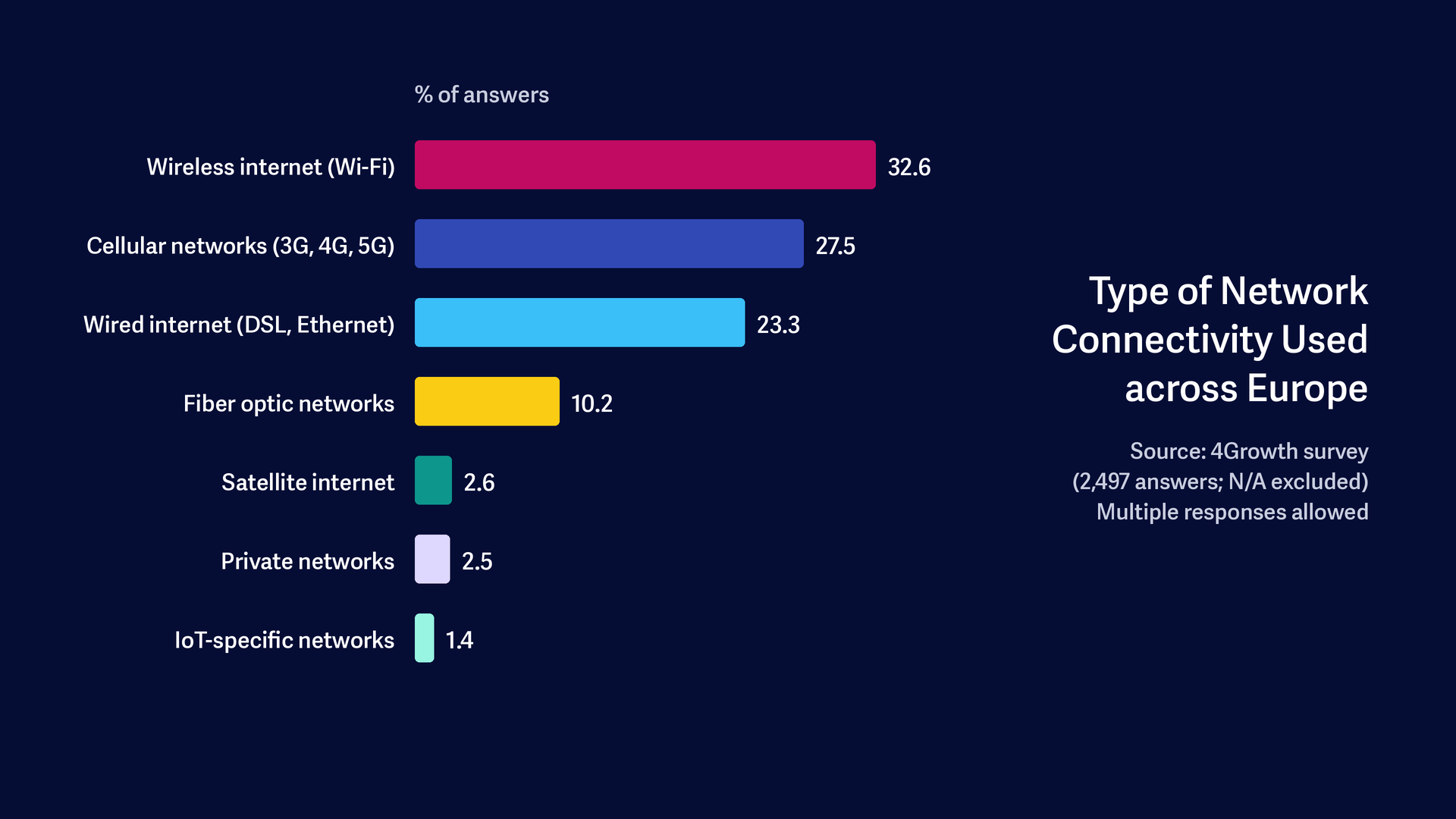
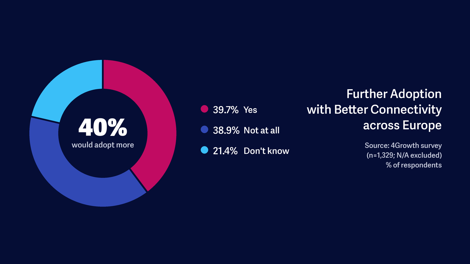
Many of these technologies depend on a reliable connection in the field, and connectivity is still limited in rural areas. 4Growth survey data suggests that respondents mostly rely on Wi-Fi, cellular and wired networks, while satellite internet accounts for under 3% of answers. Better connectivity could also unlock further adoption. Four in ten of those who answered (40%) would adopt more digital technologies with better connectivity. A similar share (39%) said they would not, and 21% did not know.
Farmers’ propensity to adopt digital technologies depends on the availability, reliability and affordability of internet access. Space technologies have a role to play in addressing connectivity constraints that limit the adoption of digital technologies in agriculture. Alongside EO and GNSS, satellite communications are increasingly being developed to extend connectivity to rural and remote areas where terrestrial coverage is limited. For example, Deutsche Telekom, Orange, Telefónica and Vodafone recently signed a letter of intent to explore a joint bid for European mobile satellite services spectrum, a step towards integrating satellite connectivity with terrestrial mobile networks. [5] This could help fill coverage gaps in underserved agricultural areas and, as a result, widen the market for digital technologies in agriculture.
To capture this growth, technology providers need to focus on what the end user needs: information that farmers can turn into practical actions on the farm. Adoption is more likely where solutions are easy to integrate into existing workflows and do not create additional complexity for farmers.
Providers can develop and scale these technologies while making them easier to adopt and use. This creates opportunities to improve usability, simplify interfaces and ensure compatibility with existing machinery and farm operations.
Further opportunities lie in integrating different technologies and data sources. Farm Management Information Systems, for example, can combine satellite data with information from sensors and machinery. Providers that bring these data sources together in a single environment can help farmers make better use of the information already available to them.
4Growth forecasts suggest that the market for these technologies will grow significantly by 2040, and the opportunity for technology providers lies in developing practical and integrated solutions that help farmers capture its value in day-to-day operations.
To explore projections across different technologies and scenarios, visit the 4Growth Visualisation Platform.
Authored by Ellesha Dunn on behalf of London Economics. Edited by Evenflow.
[1] European Commission. (n.d.). Key Policy Objectives of the CAP 2023-27. Available at: https://agriculture.ec.europa.eu/common-agricultural-policy/cap-overview/cap-glance/key-policy-objectives-cap-2023-27_en [accessed 6 October 2026].
[2] 4Growth penetration rates measure each technology’s installed base as a share of its addressable market and are not directly comparable with farm-level statistics.
[3] EUSPA. (2026). EU Space Market Report. Available at: https://www.euspa.europa.eu/sites/default/files/documents/EU_Space_Market_Report_2026.pdf [accessed 1 October 2026].
[4] The difference between EUSPA and 4Growth revenue estimates reflects different market definitions. EUSPA estimates revenues from EO data and services used in agriculture, whereas 4Growth estimates revenues from sales of the broader agricultural technologies, which draw on EO, GNSS, data from drones and other inputs. For Guidance and Controlled Traffic Farming this includes the full value of guidance-equipped machinery, which relies primarily on GNSS.
[5] Deutsche Telekom. (2026). Four European operators sign Letter of Intent to explore a joint bid for Mobile Satellite Services spectrum. Available at: https://www.telekom.com/en/newsroom/latest-updates/news/2026/10/deutsche-telekom-orange-telefonica-and-vodafone-have-signed-a-letter-of-intent [accessed 11 November 2026].
Sign up to stay informed of news, key outputs and upcoming events!